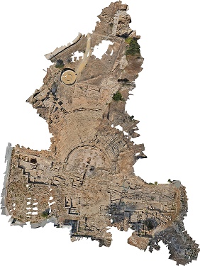
SYDNEY, AUSTRALIA—For the past 20 years, a team of archaeologists from the University of Sydney has been excavating at Nea Paphos, the capital city of Cyprus during the Hellenistic and Roman periods (300 B.C.–A.D. 400). The most recent project has focused on mapping the city’s 8,500-seat theater and the surrounding area with pole photography and photogrammetric technology. “The work now is to position the theater within its ancient urban context,” lead archaeologist Craig Barker explained in a press release. The new 3-D map revealed that the more than 160 fragments of massive granite columns found around the theater lined two main roads during the Roman period. The first road ran north-south from the harbor to the theater; the second ran east-west behind the theater. “The scale of the Roman trade in monumental architectural elements was massive. As the capital city of Cyprus at the time, it is not surprising Nea Paphos would be adorned with this architectural demonstration of Roman civic order,” Barker added. To read more, go to "Rome's Imperial Port."