

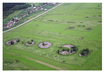
A group of researchers at Ghent University in Belgium has tested a new and inexpensive method of taking low-altitude aerial photographs and creating 3-D computer models of archaeological sites. The team chose to use a remote-controlled drone "quadro-copter" (top) —a highly stable helicopter with four sets of rotors —to carry a digital camera over a group of five kurgans (bottom), burial mounds built by the Scythian culture in central Russia between 2,500 and 2,200 years ago. Because researchers kept a precise record of the copter's position as it photographed the site, the digital images could later be combined to make a 3-D computer model using software developed by Orbit GeoSpatial Technologies. The researchers plan to use the model to make more accurate measurements of the kurgans' size and to reconstruct how they looked when they were first built. Using a drone to photograph the site was less expensive and provided better resolution than images shot from airplanes or satellites.