Newly uncovered fortifications reveal how ancient Maya rulers struggled for wealth and territory
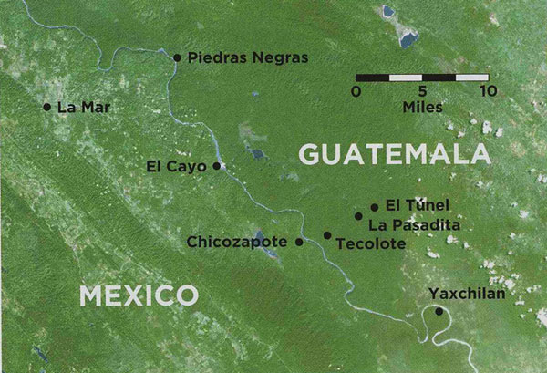
The Usumacinta River cuts a meandering path through a mountainous rain forest and forms part of an international border with Mexico on its west bank and Guatemala on its east. In the past, the land around the Usumacinta was criss-crossed by a constantly shifting web of borders as the rulers of ancient Maya cities fought wars and made alliances to expand the size and influence of their kingdoms. But little evidence of where the borders of these kingdoms actually lay had been found, until the recent discovery of a series of stone walls standing three to six feet high, strung out through a four-mile-long stretch of the rain forest. These walls, which divided the kingdoms of Yaxchilan and Piedras Negras, were used to defend Yaxchilan's northern border. The walls provide important clues about the military tactics as well as the causes of the fighting that took place during the tumultuous period 1,300 years ago when both cities were at the peak of their power.
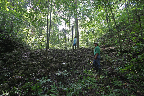
When a research team made up of Charles Golden of Brandeis University, Andrew Scherer of Brown University, and archaeologists from Guatemala's Institute of History and Anthropology came to the region in 2003, they were looking to excavate and document the ruins of the ancient towns and villages in the landscape between Piedras Negras and Yaxchilan. "Not a lot of people were looking for fortifications," says Scherer, and they weren't easy to find. The walls themselves appear to be little more than piles of stone covered with fallen leaves and jungle vegetation. "It was only over time that we started recognizing them for what they were." Part of the credit for that insight goes to the Guatemalan guides and park rangers who worked with the project, many of whom fought in this area during the Guatemalan civil war that took place in the 1980s and 1990s. The hilly terrain made the area near the Usumacinta a good hiding place for the combatants who were resisting the Guatemalan government. Conversations with these fighters helped the archaeologists think in military terms about how the landscape might have been used, which in turn helped them discover where more walls were located.
The rough terrain limits the routes that a person can easily walk through the area. Once the archaeologists knew what they were looking for, finding the walls became easy. Just outside of Tecolote, an ancient town 10 miles north of Yaxchilan, every path seems to lead to a stone wall between two hills. Evidence of watchtowers on top of the hills indicates that soldiers had a place from which to watch for approaching enemies. "They are not building one super-wall. They are building little walls between all these little hills that they can control very easily," says Golden. "It creates an easy funnel. They can catch anyone going south or north through the valleys." The walls themselves would block the path of the enemy's advance. "It's a natural control point. This is where the Maya put their walls 1,300 years ago and this is where the front was in the civil war," Scherer says. The ancient Maya warriors probably stood on the hillsides and on top of the walls, possibly taking cover behind a wooden palisade where they could hurl stones or spears at their enemies, who would have been at a severe disadvantage, bottled up in the narrow valley in front of the wall.
No evidence has been found of the walls being attacked, but the archaeological investigations are still in their early stages. Direct evidence of warfare in this region is sparse, possibly due to the speed with which human remains decay in the tropical environment. "It's actually an interesting issue with the Maya in general. We don't have a lot of skeletal remains that we can definitively attribute to war," says Scherer. He notes, however, that there is a lot of skeletal evidence for human sacrifice, which may explain what happened to those on the losing side of a battle.
While other Maya kingdoms built defensive walls around some of their cities, this is the first known case of walls being used to defend a border. This innovation represented a radical shift in the 450-year-long history of warfare between the two kingdoms. It may indicate that the two cities were fighting for new reasons. When Yaxchilan first became the capital of a Maya dynasty, in A.D. 359, its population, as well as that of its neighboring cities, was small and centralized. People could stay close to the city and take advantage of opportunities for trade, attend religious rituals, and enjoy the protection of its army. Warfare in this early period may have been focused on controlling trade routes on and around the Usumacinta River. By the time the walls were built, the cities' populations had grown much larger.
"In the Late Classic [around A.D. 700], populations start spreading out again, and I don't think that it is any coincidence at all that that is when you start seeing these kinds of conflicts and attempts to control land," says Stephen Houston of Brown University, who spent five field seasons digging at Piedras Negras. He believes that growing populations may have forced people to spread beyond the areas near the cities and look for new farmland and other sources of wealth.
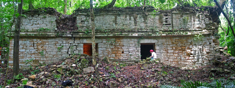
Near the walls, the team has documented a series of these settlements: Chicozapote, La Pasadita, Tecolote, and El Túnel. The warriors who defended the border probably lived in these settlements with their families. The settlements were ruled by sajals, who were counselors to the king, administrators, and war leaders responsible for defending the border and leading attacks against the kingdom's enemies. So far, the excavations have been concentrated at La Pasadita and Tecolote, which lie less than three miles away from each other. What the archaeologists have found is revealing important details about the part these settlements played in the political life of the Yaxchilan kingdom.
Construction at the border settlements seems to have begun during the reign of Yaxchilan's king Shield Jaguar III. At the time he ascended the throne, Yaxchilan had been defeated and made subordinate to Piedras Negras. Shield Jaguar III was appointed to his post by a king of Piedras Negras known only as Ruler 4. For the first 40 years of Shield Jaguar III's exceptionally long reign, he seemed to accept this arrangement, but something changed around 713. A carved stone monument in a temple in Yaxchilan's western acropolis records a series of military victories over the rulers of nearby settlements including several allied to Piedras Negras. Extending the territory under its political control may have brought more wealth to Yaxchilan, but it also may have provoked some powerful enemies. The settlements along the border appear to have been built in a hurry, as if Shield Jaguar III were racing to protect his kingdom from an impending attack. According to Golden, "the palaces at Tecolote and La Pasadita go up in probably 25 years or less, all in one go. They are just throwing them up wholesale on the landscape." The defensive walls were probably built around the same time.
The lack of archaeological sites dating to the Late Classic period in the territory north of Yaxchilan indicates that the area was essentially empty when the walls and nearby settlements were built, which allowed the king to place settlements strategically on the landscape and appoint whomever he liked to rule them. Scenes carved into the door lintels at Yaxchilan show that Shield Jaguar III's successor, Bird Jaguar IV, appointed several new sajals during his reign. Likewise, a scene carved into a panel on a door lintel in La Pasadita's largest building shows the town's sajal and king Bird Jaguar IV standing over a lord who had been defeated in battle. The king's prominent place on the monument suggests that Yaxchilan's subordinate lords were under the
king's strict supervision.
On the other hand, the area south of Piedras Negras was occupied by smaller cities such as La Mar and El Cayo, which had their own royal families and whose loyalty had to be negotiated for or bought. Golden interprets these differences to mean that the Piedras Negras kingdom had a less rigid political structure. Its subordinate lords seem to have enjoyed more freedom and autonomy. In contrast, Yaxchilan seems to have been very authoritarian, and may have had steadier allies in better locations when the time came to fight.
Among the Maya, the victors literally did write the history. Rulers were proud to commemorate their successful military campaigns, while the losers typically did not record their defeats. To get a complete history of warfare between Yaxchilan and Piedras Negras, scholars have had to study monuments in both cities. But there is a mysterious 10-year gap in the historical record between the death of Shield Jaguar III and the ascension of Bird Jaguar IV to the throne. Archaeologists refer to this period as the "interregnum." What happened during that period is still debated by scholars.
The only mention of a ruler in Yaxchilan during those 10 years comes from Piedras Negras, in a monument named Panel 3, which seems to be an attempt at propaganda as a response to Yaxchilan's resurgence. The panel shows Ruler 4 meeting subordinate lords who offer him tribute, and one of them appears to be the "interregnum" king. "Ruler 4 seems to be scolding this ‘interregnum' king of Yaxchilan and telling him ‘remember who put your father on the throne, and remember who's the boss here,'" says Golden. The name glyph of this king is partially eroded, obscuring his identity, but his presence at Piedras Negras probably means that he was either captured in war or chose to make peace and ally himself with the rival city. Houston thinks the king was in Piedras Negras by choice, and that he was purposefully removed from the monuments of Yaxchilan. "Whatever this king was trying to do at Piedras Negras, it just went against the grain of Yaxchilan," he says, "He is one of the very few historical figures who was so odious to his family an attempt was made to obliterate his memory."
By 752 Bird Jaguar IV, the son of Shield Jaguar III by one of his lesser wives, ascended the throne. He picked up where his father left off, strengthening the border against Piedras Negras and expanding the city itself by putting up or radically altering more than a dozen buildings. Monuments at the site commemorate his 20 military victories over nearby settlements. The long years of warfare between the two cities finally ended in 808 when Yaxchilan's king Tatb'u Skull III captured the last king of Piedras Negras, Ruler 7. A few years later Piedras Negras was overthrown, and parts of the city were burned. Archaeologists have found pieces of the king's throne smashed to pieces inside the palace.
In spite of his victory, Tatb'u Skull III was the last king of Yaxchilan, but no one knows exactly when his reign ended. Over a period of years the population of Yaxchilan seems to have moved away from the city. About the same time, the defensive settlements of La Pasadita and Tecolote were abandoned. The walls that symbolized the kings' desperate attempt to satisfy the need for land, security, and self-aggrandizement went unmanned. The kingdom may have become the victim of a demographic trend that the kings themselves had a hand in creating. "In order to have these communities out on the landscape, there couldn't be daily interaction between the kings and the people they governed," says Scherer. "These people out on the landscape had to have their own sort of leaders. One of the challenges that all state-level societies face is how you keep your subordinates from seeking power for themselves." With the secondary settlements now able to provide security, land, and ceremonial centers for themselves, Yaxchilan may, it is theorized, have lost its attractive power. Its population dispersed across the landscape, and the city collapsed with no war to sustain it.
Zach Zorich is a senior editor at ARCHAEOLOGY.


