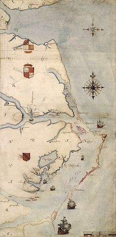
MACON, GEORGIA—An investigation led by Eric Klingelhofer of Mercer University may have found new clues into the disappearance of the lost colony of Roanoke Island. Last year, researchers discovered that a patch on a sixteenth-century map of coastal Virginia and North Carolina covered a symbol that could represent a fort. Would some of the lost colonists have moved to this location in case of an emergency? “Our best idea is that parts of Raleigh’s exploration in North America were a state secret, and the map ‘cover-up’ was an effort to keep information from the public and from foreign agents,” Klingelhofer said. Where else could a small group of the more than 100 colonists have gone to find refuge? After using satellite images to orient historic maps, the team used magnetometers and ground-penetrating radar to look for metal objects, graves, and signs of collapsed wooden structures. “We have to go in and dig some holes, I guess,” added Clay Swindell of North Carolina’s Museum of the Albemarle.


